
Bonaly ParkAnytime Orienteering
Course Type: Permanent
Terrain type: Woodland & Moorland
Location Info
/-3.2611,55.8942,11/500x400?access_token=pk.eyJ1IjoicGF1bGZyb3N0IiwiYSI6ImNscGg3eGRlMjA0cm8yaW52aGhtY2lxZjQifQ.Lc483ZPI9QPGNrBpcqqywQ)
Near: Colinton Lat,Lng: 55.8942,-3.2611 OS Grid Ref: NT211675 Postcode: EH13 0PB What3Words: ///tribal.fantastic.digs
Open an interactive map in: GoogleMap - OpenStreetMap - AppleMaps - BingMap
Directions / Parking
Upper car park is up a narrow road beyond the Scout Centre; or park on Torduff Road just beyond the bridge over the city by-pass.
Overview
Bonaly Country Park is owned by the City of Edinburgh Council and managed as part of the Pentland Hills Regional Park.
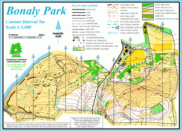
Map / Terrain Details
This map covers a small, hilly area offering some complex woodland and open moorland with many rock features, on the northern edge of the Pentlands. A major track bisects the area, and there are other well-established paths as well as some recent mountain bike tracks.
Course Information
Course 1
1.2km, 8 controls, 65m climb.
A simple course for beginners or families with small children.
Course 2
1.2km, 80m climb, 7 controls.
Similar to Course 1.
Course 3
2.2km, 160m climb, 14 controls.
Needs careful map-reading and distance judgment to locate controls that are not on paths.
Course 4
2.5km, 210m climb, 13 controls.
This course has been planned to present a demanding physical and navigational challenge for more experienced orienteers.
Maps packs (paper or digital) can be obtained by emailingESOC. Donations will be welcome via online banking (details on request).
Safety Notes
Participants take part at their own risk and are responsible for their own safety whilst using the course.
Steep terrain and paths on all courses which can be slippery if wet or dry.
The area is well used by the public, including dog walkers and mountain bike