
Corstorphine HillAnytime Orienteering
Course Type: Permanent & Virtual
Terrain type: Woodland
Location Info
/-3.2814,55.9607,11/500x400?access_token=pk.eyJ1IjoicGF1bGZyb3N0IiwiYSI6ImNscGg3eGRlMjA0cm8yaW52aGhtY2lxZjQifQ.Lc483ZPI9QPGNrBpcqqywQ)
Near: Corstorphine Lat,Lng: 55.9607,-3.2814 OS Grid Ref: NT201749 Postcode: EH4 7BL What3Words: ///bucket.jokes.hips
Open an interactive map in: GoogleMap - OpenStreetMap - AppleMaps - BingMap
Directions / Parking
There are 2 options depending on the course (see below)
A) On or near Clermiston Road North EH4 7BL Grid Ref NT201749 What3words: ///bucket.jokes.hips (this is the location marked on map)
B) On Cairnmuir Road EH12 6LP Grid Ref NT205735 https://what3words.com/lows.owners.book
Overview
New Courses for 2024
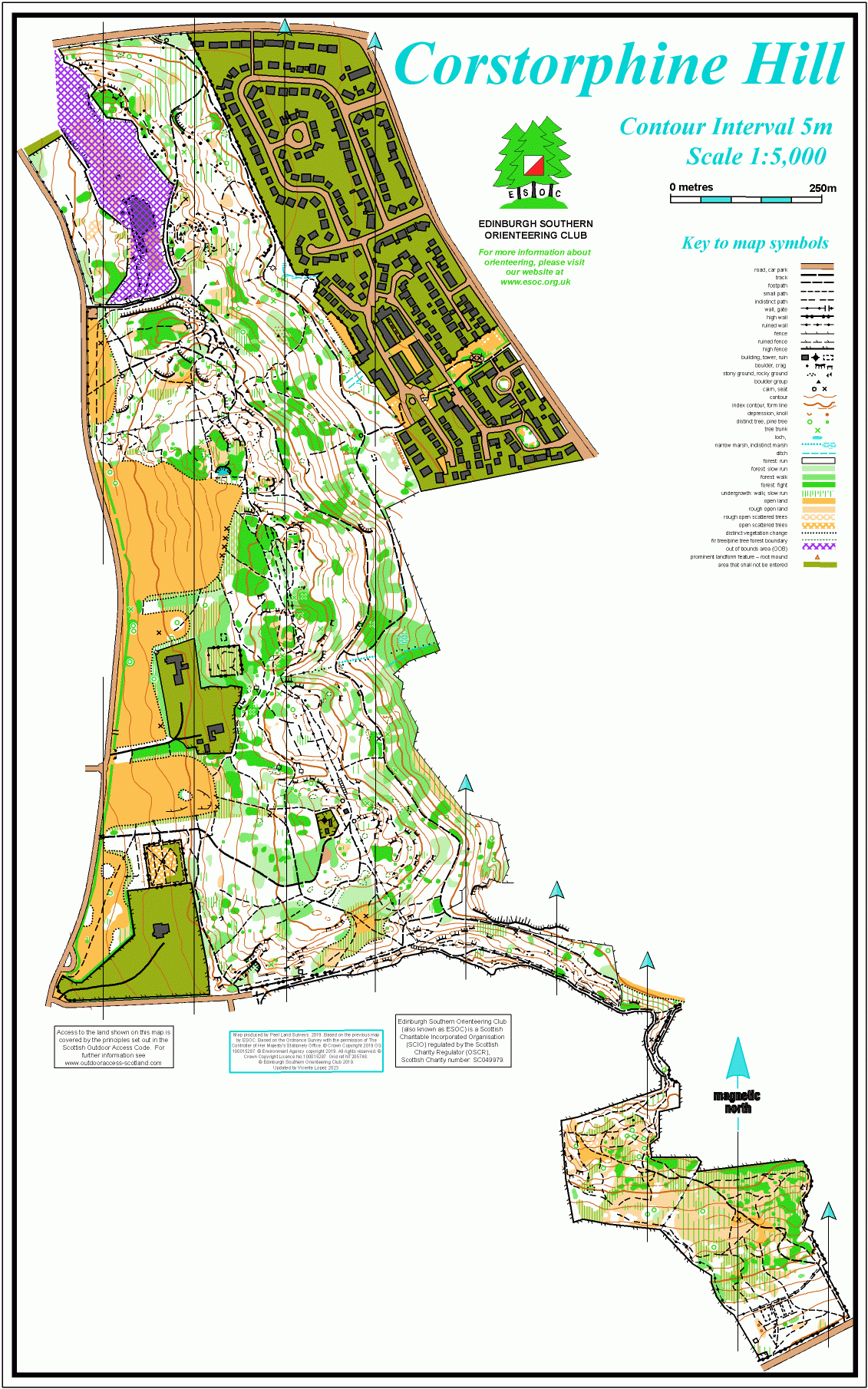
This is a long thin area in the west of the city, bordering the Zoo. It’s a Local Nature Reserve, managed by the City of Edinburgh Council https://www.edinburghoutdoors....
Map / Terrain Details
Mostly wooded, with some steep slopes to the east, and open grassy areas on the western side. There are lots of rock features throughout the area. The southern extension to the map is less rocky, a mixture of open and wooded terrain. There’s a good path network throughout which in places is deceptively complex
The area is well-used by the public, including dog walkers, mountain bikers and the occasional horse riders.
.
MapRun Directory Path
In the MapRun app, click on Select Event then navigate to:
UK->Scotland->Edinburgh->Corstorphine Hill
Then select the Course you want (See below). Click on Go to Start to see map on your phone
Course Information
There are 8 colour-coded courses available plus an All controls Scatter Map using the Permanent Orienteering Course (POC) posts. See below for an explanation of the colour levels.
Explanation of colour coded courses here
NB In the summer it is possible that some of the posts may become obscured by undergrowth, but the MapRun app will still beep.
Maps for each of the courses are available to download using the links below
These courses are also available as Virtual Orienteering Courses (VOCs), using the MapRun app on a smartphone.
NB
- The Start/Finish point for the 8 colour coded courses is one of 2 points (A and B). See under Directions.
- In the summer it is possible that some of the shorter posts will become obscured by undergrowth, you can use the MapRun app to confirm the location of such controls.
All the Map PDFs listed below have 2 pages, with the legend and instructions on the reverse.
POC Yellow 2 - Yellow Standard
1.3km, 65m climb, 7 controls.
A simple course for beginners and families with small children (from Start B).
Download Yellow Course 2 map
POC Yellow 1 - Yellow Standard
2.1km, 65m climb, 6 controls.
Harder; not all controls are on paths (from Start A).
Download Yellow Course 1 map
POC Orange 1 - Orange Standard
2.5km, 110m climb, 10 controls.
This course requires accurate map reading and distance judgment through the complex terrain (from Start B).
Download Orange Course 1 map
POC Orange 2 - Orange Standard
2.6km, 125m climb, 10 controls.
Similar to course 1 (from Start A).
Download Orange Course 2 map
POC Orange 3 - Orange Standard
2.8km, 130m climb, 10 controls.
A variation of Orange course 2 (from Start A).
POC Long Orange 1 - Orange Standard
3.4km, 150m climb, 13 controls.
This course requires accurate map reading and distance judgment through the complex terrain. Similar to Orange 1 but longer (from Start B).
Download Long Orange Course 1 map
POC Long Orange 2 - Orange Standard
3.5km, 155m climb, 13 controls.
Similar to Long Orange 1 (from Start A).
Download Long Orange Course 2 map
Green Course
This Green course, the hardest technical course, has its own start and finish location as shown on the map and is for experienced orienteers - some controls are not on POC posts but will beep if using MapRun
3.4km, 165m climb, 14 controls.
Download Green Course map
Scatter Course
All 21 POC controls.
Make up your own course (Start Anywhere)
Download Scatter Course map
Maps packs (paper or digital) can be obtained by emailing ESOC. Donations will be welcome via online banking (details on request)
Safety Notes
Participants take part at their own risk and are responsible for their own safety whilst using the course.
The area is well used by the public, including dog walkers, mountain bikers and the occasional horse riders.
There are some steep slopes and rocky areas which are easily avoided, and the path network in the wood is deceptively complex
There are 2 Starts – A in the north accessed from Clermiston Road North and B in the south accessed from Cairnmuir Road.