
Harlaw ReservoirAnytime Orienteering
Course Type: Virtual
Terrain type: Forest
Location Info
/-3.3098,55.8756,11/500x400?access_token=pk.eyJ1IjoicGF1bGZyb3N0IiwiYSI6ImNscGg3eGRlMjA0cm8yaW52aGhtY2lxZjQifQ.Lc483ZPI9QPGNrBpcqqywQ)
Near: Edinburgh Lat,Lng: 55.8756,-3.3098 OS Grid Ref: NT181655 Postcode: EH14 7AS What3Words: ///tennis.cook.leave
Open an interactive map in: GoogleMap - OpenStreetMap - AppleMaps - BingMap
Directions / Parking
Large car park adjacent (which can often be very busy), follow brown signs.
Overview
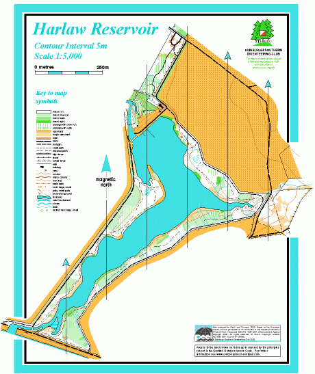
Harlaw Reservoir is near Balerno. The dam was constructed in the 1840s to provide water for the city. The reservoir is no longer used for the public water supply, but along with the neighbouring Threipmuir Reservoir it now provides flood prevention water storage. There’s a small visitor centre near the dam. The map covers open land NE of the reservoir and the paths around the wooded shores and across the Threipmuir dam.
Harlaw falls within the Pentland Hills Regional Park
Map / Terrain Details
Narrow strip of forest surrounding Harlaw reservoir.
MapRun Directory Path
In the MapRun app, click on Select Event then navigate to:
UK->Scotland->Edinburgh-> Harlaw
Then select the Course you want (See below). Click on Go to Start to see map on your phone
Course Information
Short
2.1km. There and back on the east side of the reservoir, with controls in the woodland on the banks of the Reservoir.
Download Short Map
Long Course
3.6km. This course has a route choice option which takes you right round Harlaw Reservoir.
Download Long Map
Safety Notes
Participants take part at their own risk and are responsible for their own safety whilst using the course.