
Bilston Glen and MavisbankSat 16 May
Local event
Local event
Explanation of event types
Local events are usually low key and in the 'localised' area, ideal for newcomers to try the sport and Training events are non competitive and used for training and coaching, aimed at members of the club, but they can attract people from neighbouring clubs, and are often ideal for newcomers to try the sport. Regional events attract participants from around the local Region, National events are high quality competitions that will attract people from far away, Major events are Major Events such as a British Championships. Virtual events are where there are no physical controls being used. Your presence at a control is registered using an App on your mobile phone, normally the free MapRun App.
Terrain type: Parkland & Woodland & Moorland
Results
Officials' Reports
Planner’s comments
I hope you all enjoyed the new area and the courses. From my first visit I felt it had some nice quite tricky terrain. The problem was linking the good bits together while avoiding the really steep slopes, and not having too much easy path running. I hope people on the harder courses felt I found good compromises here, although it meant quite a lot of short legs to turn corners. I even spoke to a few people who made mistakes around the multiple paths on the old mine bings – too many paths can be quite tricky if you don’t pay full attention. For the easier courses, the paths provided straightforward routes, but with enough junctions to make for some interest, I hope. I heard that several people on the Orange course had problems with the first control – in retrospect I should have included an easy one first to get you going, before one at full technical difficulty 3.
Most of you will have met some underfoot problems. The nettles were not as bad as I feared (based on their state in late April), but still unpleasant in places. In December there were still remains of shoulder high undergrowth, so you wouldn’t want to be there in summer! Brambles were also an issue in places. One path on the Yellow course seemed fine in December, but required an hour of pruning a week before the event to make it passable for kids (and I’ve still got some thorn pricks on my hands!). A lot of the paths were extremely muddy in December, and other terrain was pretty boggy. Thankfully that had improved a lot by the event – probably the worst mud was faced by the White course, starting along a big track much used by horses.
There was some interesting detail on the less steep section of the slope above the River North Esk. But I feared it couldn’t be used as I looked at the really steep slope at the south end, probably quite dangerous if wet. Thankfully I then came across the animal track that provided an OK escape on to the path above.
Joining Mavisbank to Bilston Glen required the short road routes and a fairly long path run in one direction. So it didn’t make sense to have a shorter loop once you got there, and only the Blue course got to experience this rather different and varied terrain. The course avoided the most northerly part of Mavisbank because this was on a line of possible works given to us by the landowner. Only after the course was finalised did we realise this was the Mavisbank House access road, for which planning permission had only just been granted. There was of course nothing on the ground yet, and I could have used an earlier course shape that visited this part and avoided the long run back along lower part of the slope.
Peter Halling
Organiser's comments
Such a buzz about a new area! The large entry included the curious (why was this never mapped before?), the local (lovely surprise to find this on our doorstep), the increasing number of young families who find this a fun activity, and the regular orienteers.
Meticulous planning by Peter Halling made the best use of the complex terrain. The Bayne Memorial Hall made a very welcoming indoor space for Registration, Download and the OZONE Junior Activity area. The ESOC volunteer team coped with the remote Start and the large numbers with slick efficiency. And the sun shone on us all day. We're still buzzing!
Grateful thanks to the three landowners who gave permission :
The Esk Valley Trust (Hewan Wood)
The University of Edinburgh Lands Department (Bilston Glen)
Historic Scotland (Mavisbank)
Janet Clark
Overview
New area - newly mapped sloping woodland around the River North Esk and Bilston Burn, never used for orienteering before. Popular area for walking, cycling and horse riding.
The map covers several privately owned areas and SSSIs, and as such there are out of bounds areas and taped routes. on some courses. Please read the course safety information carefully.
Event Centre with toilets and the popular Ozone area with O-themed games and activities for all juniors.
Pre-event Information
Location Info
/-3.1533,55.8747,11/500x400?access_token=pk.eyJ1IjoicGF1bGZyb3N0IiwiYSI6ImNscGg3eGRlMjA0cm8yaW52aGhtY2lxZjQifQ.Lc483ZPI9QPGNrBpcqqywQ)
Near: Loanhead Lat,Lng: 55.8747,-3.1533 OS Grid Ref: NT279651 Postcode: EH20 9BL What3Words: ///fishnet.overpower.builders
Open an interactive map in: GoogleMap - OpenStreetMap - AppleMaps - BingMap
Directions / Parking
The event will be based in the Bayne Memorial Hall, Burghlee Crescent, Loanhead, Midlothian, at postcode EH20 9BL and What3words ///fishnet.overpower.builders
Parking in the surrounding streets, early arrivals may find some space in a small car park at What3words ///frame.winds.teaspoons.
Registration and Download will be in the hall which also has toilets and space to leave bags.
There are plenty of options for getting there. Please use public transport or share cars if at all possible.
By car: Parking in residential streets close to Bayne Memorial Hall in Loanhead, please be considerate of local residents. Car parks are shown on the OpenStreetMap link (zoom in).
Car share: Edinburgh based orienteers are welcome to join the newly expanded Edinburgh Orienteers - Car sharing WhatsApp group. Please contact email hidden; JavaScript is required for the joining link.
Public Transport Options
By Bus:
From Edinburgh Lothian Bus 37, from the east (Musselburgh) East Coast bus 140/141. Get off at bus stop George Avenue, walk through Memorial Park and then down Burghlee Crescent (about 300m).
By Bike:
A variety of quiet cycle route maps, including to get to south Edinburgh, are available on the Edinburgh City Council Quiet Routes web pages and these can be used to join up with Midlothian Council's waymarked cycle routes network (including the Loanhead to Roslin cycle route which goes through the competition area), download maps here
It will be possible to lock your bike at the event centre and there will be space to leave bags.
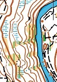
Map / Terrain
All courses visit wooded glens around the River North Esk and Bilston Burn. Some slopes are very steep, but there are less steep parts with spur and re-entrant contour detail. There are also bings and other features from former mining. The Blue course also visits Mavisbank, which is semi-open, with some woodland, marshes and thickets. All courses finish in Burghlee Park, which has open grassland and some woods.
There is a path network throughout, and some paths can be very wet and muddy. Even the TD5 courses will involve significant sections on paths, connecting more interesting terrain. Motorbikes use parts of the area, and you may find new unmapped tracks.
There are patches of brambles and nettles, which can mostly be avoided by slight deviations. The nettles were still quite low in late April, but are growing fast. Full leg cover should be worn!
Several areas adjoining the terrain used are out-of-bounds, and will be marked as such on the map with red hatching. The lower part of the deep gorge in Bilston Glen is an SSSI. There should be no temptation to cross these steep, slippery and craggy slopes.
Map: 1:7500 with 5 m contours, by Peel Land Surveys 2025, with in-house updates in 2026. See map snippet above for an example of the terrain
Control descriptions will be printed on the map, there will be no loose copies.
Safety Notes
General Safety (please note any course specific information below)
- Other Users: The area is very well used by the general public, including dog walkers, runners, cyclists, motorcyclists and horses . Please be considerate to other users and give way when necessary.
- Please respect the Out of Bounds areas marked on the map with cross-hatching.
- Full leg cover required - nettles and brambles abound.
- Dogs: Competitor’s dogs are allowed and should be kept under very close control at all times.
- SAFETY NOTE RE DOGS: Please give any dog walkers you encounter whilst running on your course extra space ie don’t run too close, especially if their dog/dogs are off lead. This applies to all competitors, not just those running with a dog. We always need to respect other people's right to be there.
- Course Closure Time: All courses have a closure time of 4pm after which controls will start to be brought in (before it gets dark. All competitors should be back at Download by 4pm.
- You must report to Download even if you do not complete your course, so we know you are back safely, and we don’t have to mount a search for you.
- Please check the weather forecast on the day and dress appropriately. parts of the area may be muddy so please wear the most appropriate footwear for the course you are entering.
Course Information
As usual at ESOC events there will be courses to suit all abilities
- White, Yellow for young juniors
- Orange for improvers (the shape of the area doesn't allow for a Long Orange))
- 3 Courses for more experienced orienteers
Plus the popular Ozone area with O-themed games and activities for all juniors will be set up in the hall.
Provisional course lengths here and please read the additional information below the table
NB Any Under 16s on the Blue course must be accompanied by an adult.
| Course | TD | Length | Climb | No of controls | Map Size (TBC) |
| Blue | 5 | 7.1km | 220m | 28 | A3 |
| Green | 5 | 4.2km | 150m | 16 | A4 |
| Short Green | 5 | 3.0km | 85m | 13 | A4 |
| Orange | 3 | 2.9km | 85m | 13 | A4 |
| Yellow | 2 | 2.3km | 40m | 11 | A4 |
| White | 1 | 1.2km | 10m | 9 | A4 |
- Some controls will be hanging from trees or similar with the SI unit attached, rather than on stakes – this is at the request of the landowner.
- There are patches of brambles and nettles, which can mostly be avoided by slight deviations. The nettles were still quite low in late April, but are growing fast. Full leg cover should be worn!
- Several areas adjoining the terrain used are out-of-bounds, and will be marked as such on the map with red hatching. The lower part of the deep gorge in Bilston Glen is an SSSI. There should be no temptation to cross these steep, slippery and craggy slopes.
- All but the White course cross the Loanhead to Roslin cycle path, and the Yellow course uses its viaduct over Bilston Glen. The route to the start also uses part of this path. Beware of fast cyclists, and keep to the sides when going along the path.
- Unfortunately even the White course would be very difficult on wheels, because of rough and muddy paths.
- One leg on the Blue and Green courses requires a short section on a very steep slope. It is recommended to cross this on an animal track, which will be marked by tapes. Another leg on the Blue course has a likely route descending 10 m down a steep slope below a path. The best starting point to descend will be marked by a tape. Both these taped bits will be noted in the descriptions.
- The Blue course has two short sections along a minor road. For this reason, unaccompanied under-16’s cannot be allowed on the Blue course. The road is fairly quiet, but narrow and winding and some sections will be “timed out”, so you don’t need to rush. (The time taken on that leg will not be included in your overall run time, provided it is under a generous limit – no long rests!) If a car does come, you are advised to walk or even stop while it passes. Each timed-out section will start with a control just before you reach the road, and end with one just after you leave the road. The points where you leave the road will be marked with tapes.
- There are several fences on the Mavisbank section of the map used by the Blue course. These are mapped as crossable, but some are quite hard to cross, with barbed wire tops. Two near controls are overprinted with a red line to indicate it is recommended to avoid them, and a suggested crossing point is also marked.
Entry Details
Pre-entry using RaceSignUp will be required for this event. Entries will open at 10am on Monday 4th May and will close at 6pm on Friday 15th May.
However to be guaranteed a course map on waterproof paper for your chosen course you MUST pre-enter by 8pm on Monday 11th May.
On the RaceSignUp page (first time users will need to create an account) you can view an entry list for all competitors and their chosen start blocks (scroll down to the Start List section). Please note that you can arrive at the start any time within your block.
Entry Fees:
| Category | BOF Members | SOA Members | Non Members |
| Seniors (26 and over) | £4.50 | £5.50 | £6.50 |
| Juniors/Students/Young adults (21-25) | £2.50 | £3.50 | £4.50 |
As well as individuals the entry system also allows pairs, groups or families who wish to go round a course together (sharing one map and dibber) to enter using a sliding scale of fees. Full details of how to enter pairs and groups (or as a Student) are on the RaceSignUp entry page.
Example fees for Pairs or Family/Groups - maximum of 4 people per group. Groups with more than 4 should split up into smaller groups but can still start at the same time.
| Category | BOF members | SOA only members | Non members |
| Senior Pair | £5.50 | £6.50 | £7.50 |
| Junior Pair | £3.00 | £4.00 | £5.00 |
| Senior/Junior Pair | £5.00 | £6.00 | £7.00 |
| Group - 1 Senior + 2 Juniors | £5.50 | £6.50 | £7.50 |
| Group - 2 Seniors + 1 Junior | £6.00 | £7.00 | £8.00 |
SportIdent (SI) electronic timing will be used.
We have SI dibbers for hire free of charge via the pre-entry system but there is a £30 charge if lost.
If you would like to buy your own SI-Card then a variety are available directly from SportIdent UK. The choice may be confusing and it may help you to know that the SI-Cards which ESOC hires out are very similar to the most basic model shown on the linked page - the SI-Card 8.
Registration and Start times
Registration: Will be open from 12:15 -14:15 in the event centre for
- Entry on the Day (EOD) if maps are still available. Payment by cash or card/contactless. Please try to have the correct money if at all possible.
- Collection of hired dibbers, White and Yellow maps:
- Advice and help for beginners
Start Times: From 13:00 to 14:30 with course closure at 4pm.
The Start is about 500m from the assembly (Bayne Memorial Hall), following a taped route. This involves a short steep and narrow descent path, which is not suitable for wheeling. There is a longer route down a ramp that is good for wheeling. But unfortunately even the White course would be very difficult on wheels, because of rough and muddy paths.
The finish is immediately next to the hall.
Facilities
- There are toilets at the event centre or plenty of big supermarkets with facilities to visit on the way eg at Straiton
- A first aid kit and assistance from a qualified club first-aider will be available at Registration
Dog restrictions
Well-behaved dogs on a lead welcome on the courses but are not allowed in the hall..
Contacts / Officials
Advance enquires: email hidden; JavaScript is required
Entry enquiries: email hidden; JavaScript is required
Nearest A&E Hospital
Please see under Important Event Information in the side panel.
NHS Urgent care search