
CademuirSun 13 Sept
Scottish Orienteering League (SOL 4)
National event
Explanation of event types
Local events are usually low key and in the 'localised' area, ideal for newcomers to try the sport and Training events are non competitive and used for training and coaching, aimed at members of the club, but they can attract people from neighbouring clubs, and are often ideal for newcomers to try the sport. Regional events attract participants from around the local Region, National events are high quality competitions that will attract people from far away, Major events are Major Events such as a British Championships. Virtual events are where there are no physical controls being used. Your presence at a control is registered using an App on your mobile phone, normally the free MapRun App.
Terrain type: Moorland
Results
Officials' Reports
Planners' Report
I hope you all enjoyed your courses on Cademuir. We were certainly fortunate with the weather — while putting controls out on Saturday, the wind on the tops was strong enough to make standing difficult. Cademuir is very exposed in rough weather, so Sunday’s sunshine and calm transformed the experience.
Cademuir is a beautiful but quite awkward area to plan on. The best running and navigation is along the higher ridge, with its short grass, intricate contours and rock detail. By contrast, the lower eastern slopes have increasing areas of bracken and heather, while the slopes on either side of the ridge become very steep and less enjoyable. Planning 13 courses therefore involved trying to make maximum use of the runnable ridge and the ground above the bracken and heather, while avoiding unnecessary climb and keeping the shorter courses within appropriate distance and difficulty.
Most of the longer courses therefore used the Far Start, reducing some of the climb and starting competitors above much of the heavier vegetation. Some shorter courses inevitably had to remain in the more limited eastern part of the area and, in hindsight, a few were perhaps a little technically straightforward. With the fast, dry conditions on Sunday, some winning times were consequently quite quick; had we experienced Saturday’s wind and weather, I suspect they would have felt rather different!
It was great to hear so much positive feedback afterwards. Competitors seemed to enjoy the combination of fast running and contour navigation, and Routegadget shows some excellent contouring and precise navigation.
Although some minor map updates were made, I think Cademuir would now benefit from a fuller refresh, particularly of the rock detail and changing vegetation. If suitable parking or access closer to the main ridge could be found for a future event, it might also allow more courses to make use of the more intricate and enjoyable higher ridge tops — with their stunning views.
Many thanks to Lindsey Knox for her patient and very helpful controlling and coaching throughout, I learnt a lot, and to the whole ESOC team for making the event run so smoothly, including everyone who helped with putting out and collecting controls. My legs were certainly grateful by the end!
Thanks to everyone who came, and I’m glad Cademuir gave us such a fine day.
Peter O’Hara (ESOC)
Controllers' Report
Cademuir is a really awkward place to plan easy and short courses as well as the logistics of getting controls out with no easy access for a vehicle. Peter managed both aspects well and, I hope he won't mind me saying this, as a relatively inexperienced planner of SOL level he did a good job. We were blessed with lovely weather on the day and some courses turned out to be on the short side but if we'd had the strong winds we experienced on Saturday putting out the controls it would have been a completely different story. The ESOC team were their usual efficient selves as regards all the non-planning parts, and the Starts/Finish/Download etc all seemed to work without a hitch (apart from a tiny Download hitch near the end which was promptly sorted out !). Well done all.
Lindsey Knox (RR)
Organiser’s Report
A big thank you to everyone who came along to the Cademuir SOL. It’s a busy time of year in the orienteering calendar and it was gratifying that in the end the event attracted just over 200 entries.
Logistics are difficult at Cademuir, largely because of the long distance from the Event Centre at Peebles High School to Starts placed in locations that were a compromise between a tough walk for up to 40 minute to reach them and a location that reduces the climb on the courses. I think Peter, as Planner, did a good job.
Because the hill is exposed and relatively remote, we doubled down a bit on safety with a first aid station halfway up the hill and a tight check on carrying a whistle. Luckily, the weather was very good and we didn’t need to make a light jacket compulsory. We also experimented with radio control links between the Starts and Finish and the Event Centre (thanks to Robin Strain for setting this up) so as to keep a real-time record of who was out on their course and who was back.
Peebles High School – being rebuilt after a fire - is a good Event Centre, although a bit tight on parking. Thanks to everyone for parking sensibly. And a huge thank you to all the ESOC members who volunteered to help – I think they ranged in age from their teens to about 80 years old. Volunteering is an issue in orienteering, especially in small clubs, with a packed events calendar, competing personal commitments, increasing sophistication of events and an aging membership. Also, many thanks to Lindsey Knox, Controller, whose comprehensive knowledge of our sport is incredibly valuable.
We are grateful to Ms Patricia Anderson for permission to run on Cademuir Hill, sadly she passed away this week, we are grateful that she has been a supporter of ESOC over the years and we send our condolences to her family. We would also like to thank Peebles High School for the use of their campus.
Roger Scrutton (ESOC)
Overview
Fourth event in the 2026 SOL series.
The Final Details document and the Start List with start times are here. NB Some start times have been adjusted so please check your time. Cademuir SOL4 13Sep26 Final Details Cademuir SOL4 13Sep26 Start List
Scottish Orienteering League
The Compass Point Scottish Orienteering League (SOL) provides a series of high quality events throughout Scotland’s countryside. High quality venues, maps and quality courses are the key aims and each of the events per year is organised and hosted by a different Scottish club.
Pre-event Information
Location Info
/-3.1927,55.6451,11/500x400?access_token=pk.eyJ1IjoicGF1bGZyb3N0IiwiYSI6ImNscGg3eGRlMjA0cm8yaW52aGhtY2lxZjQifQ.Lc483ZPI9QPGNrBpcqqywQ)
Near: Peebles Lat,Lng: 55.6451,-3.1927 OS Grid Ref: NT250397 Postcode: EH45 9HB What3Words: ///shadowed.cabs.decent
Open an interactive map in: GoogleMap - OpenStreetMap - AppleMaps - BingMap
Directions / Parking
The event will be based at the Sports Centre of Peebles High School with registration, download, bag drop, toilets, Junior OZone and ScotJos cake stall
By vehicle: From the A72 at the west end of Peebles High Street, beside the Old Parish Church, cross the Tweed Bridge. At the second right after the bridge, fork right onto Springhill Road that takes you uphill. Continue for approximately 400 m and take the first right onto Springwood Road before the traffic lights, signed for Peebles High School.
Continue up Springwood Road to the school. Event parking will be available in the designated school parking areas, including the staff car park and bus parking area, and where directed along the outside of the school boundary wall.
If the school parking is full, competitors should avoid parking in the nearby narrow residential streets. Please use parking spaces back on Springwood Road where available, or Kingsmeadows public car park beside the River Tweed, and walk back to the Event Centre.
Sports Centre Entrance / Reception: what3words ///voter.fishery.grasp
Edinburgh based orienteers are welcome to join the newly expanded ESOC car sharing WhatsApp group. Please contact email hidden; JavaScript is required for the joining link.
Public Transport Options
By bus: X62 Borders Bus runs an hourly service from Edinburgh on a Sunday, it takes about an hour and 15 minutes and there is a 0.6 mile walk at the Peebles end. TBC
Any cyclist will be able to lock their bikes at the event centre
Map / Terrain
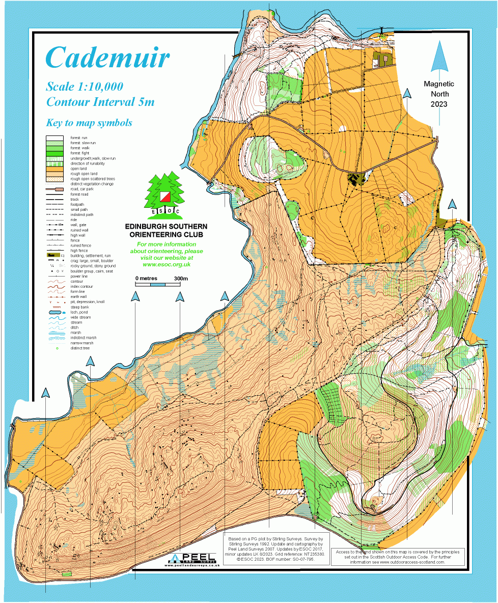
Terrain: Cademuir is predominantly open moorland with intricate contour and rock detail. Much of the open hillside, particularly that used by the longer courses, is highly runnable.
In the eastern part of the map there are areas of bracken and heather which affect some controls and route choices, and running can be slower there. Bracken and heather can also obscure uneven ground in places.
There are numerous small sheep tracks and farmer buggy tracks which are not mapped. Some of the mapped paths and tracks are also relatively indistinct on the ground. Competitors should therefore navigate from using multiple map features rather than assume that every track visible on the ground is mapped.
There is some loose stone and scree in places, particularly on steeper slopes, and competitors should take care, especially on descents.
Area last used in 2023, route gadget here
Map: Based on 2007 version by Peel Surveys updated for 2026. Contour interval 5m. Layout revised 7th September.
- NB The longer courses will use a scale of 1:10,000 and the shorter courses will use a scale of 1:7500 (see the Course table below)
- All maps will be printed on A3.
- Black, Brown and Long Orange will have a map flip and will be printed double-sided. All other courses will be on a single side.
- All control descriptions will be IOF pictorial/symbolic descriptions, printed on the competition maps, with loose control descriptions available at the Starts.
Safety bearing is “Northeast / 45 degrees” and an emergency telephone number will be printed on the maps
Safety Notes
General Safety (see also under Course safety below)
- Other Users: This area is very well used by the general public, including dog walkers, runners and horse-riders. Please respect their right to be there at the same time as you are orienteering.
- Dogs: Please give any dog walkers you encounter whilst running on your course extra space ie don’t run too close, especially if their dog/dogs are off lead.
- Competitors dogs are not allowed on the courses but may be walked to the Starts, and must be kept strictly on a lead at all times on the hill because of the presence of sheep and farmer warnings.
- Weather: Cademuir is a very exposed hill and weather conditions can change quickly. Competitors should come prepared for poor weather even if conditions at the Event Centre seem OK. In the event of very bad weather, we may make cagoules compulsory. Notices will be posted where the route to the starts leave the car park. Please come prepared for this.
- Carrying a whistle will be compulsory for all competitors
- Shorts may be worn, subject to the weather and conditions on the day. However, full leg cover is recommended because of areas of bracken and heather and the potential presence of ticks. Competitors should check themselves carefully for ticks after their run. If you have any doubt, you should seek medical advice.
- Hygiene: There will be sheep on the hill during the event, all competitors should wash their hands thoroughly after the event and please do not be tempted to drink from streams.
- Courses Close at 14:30. All competitors, whether or not they complete their course, must report to Download at the Event Centre no later than 15:15. Competitors should allow sufficient time for the return journey.
Course Information
The usual courses offered at SOL events as per the 2026 SOL guidelines, see the details here.
There will be 2 Starts, with both starts following the same route to the area - which starts along pavements for approx 1km, with 3 residential road crossings (which should be quiet on a Sunday) - then through a short wood section up on to the open hillside. The route to the Far Start passes close to the Near Start.
- Near Start (for courses 10-13) which is approx 1.6km with 75m of climb in the final 600m
- Far Start (for courses 1-9) which is approx 2km with 130m of climb in the final 1km. The walk to the Far Start involves a substantial and fairly steep climb. Allow at least 30 minutes from the High School to the hillside to reach the Far Start, particularly juniors, older competitors and slower walkers.
There is approximately a 1.5 km predominantly downhill/flat walk from the Finish back to the school - around 20 minutes walk, and everybody must return to Download.
There will be a clothing drop tent close to the Near Start which can be accessed on the walk back from the Finish.
NB Course lengths are now final
| Course No | Colour | TD | Junior | Senior | Length | Climb | #Controls | Map Scale | Start | ||
| Men | Women | Men | Women | ||||||||
| 1 | Black | 5 | M21 | M-E | 9.8km | 450m | 22 | 1:10000 | Far | ||
| 2 | Brown | 5 | M20 | M35 | W-E | 8.2km | 360m | 21 | 1:10000 | Far | |
| M40 | W21 | ||||||||||
| 3 | Short Brown | 5 | M18 | W20 | M45 | W35 | 6.7km | 275m | 17 | 1:10000 | Far |
| M50 | |||||||||||
| M21S | |||||||||||
| 4 | Blue | 5 | M16 | W18 | M55 | W21S | 5.4km | 255m | 14 | 1:10000 | Far |
| M20S | M60 | W40 | |||||||||
| M35S | W45 | ||||||||||
| M40S | |||||||||||
| 5 | Short Blue | 5 | M18S | W16 | M65 | W35S | 4.6km | 160m | 12 | 1:10000 | Far |
| W20S | M45S | W50 | |||||||||
| M50S | W55 | ||||||||||
| M55S | |||||||||||
| M70 | |||||||||||
| 6 | Green | 5 | M16S | W16S | M75 | W60 | 3.7km | 120m | 11 | 1:10000 | Far |
| W18S | M60S | W65 | |||||||||
| W40S | |||||||||||
| W45S | |||||||||||
| 7 | Short Green | 5 | M80 | W70 | 3.1km | 90m | 10 | 1:10000 | Far | ||
| M65S | W50S | ||||||||||
| W55S | |||||||||||
| 8 | Very Short Green | 5 | M85 | W75 | 2.6km | 65m | 11 | 1:7500 | Far | ||
| M90 | W80 | ||||||||||
| M70S | W85 | ||||||||||
| M75S | W90 | ||||||||||
| W60S | |||||||||||
| W65S | |||||||||||
| W70S | |||||||||||
| 9 | Light Green | 4 | M14 | W14 | 2.8km | 90m | 11 | 1:10000 | Far | ||
| M16B | W16B | ||||||||||
| 10 | Long Orange (aka Red) | 3 | M21N | 4.6km | 185m | 17 | 1:7500 | Near | |||
| 11 | Orange | 3 | M12 | W12 | W21N | 2.9km | 100m | 11 | 1:7500 | Near | |
| M14B | W14B | ||||||||||
| 12 | Yellow | 2 | M10 | W10 | 2.4km | 90m | 9 | 1:7500 | Near | ||
| M12B | W12B | ||||||||||
| 13 | White | 1 | M10B | W10B | 1.3km | 80m | 7 | 1:7500 | Near | ||
For younger juniors, instead of a String Course, there will be Junior OZone with O themed games and puzzles in the Registration/Download hall.
Entry Details
Pre-entry via RaceSignUp (RSU) is required for this event and note the key dates below.
- Entries open in RaceSignUp at 10:00 on Monday 24th August – enter by selecting a course by colour. Individual "preferred" start times can be pre-selected on entry but will not be displayed on the RSU page.
- Closing date for online entries is Monday 7th September at 23:59.
- Late entries by email to email hidden; JavaScript is required may be accepted, if maps are still available up to 23:59 on Wednesday 9th September to allow final start times to be allocated.
- Number of maps available will be listed on RaceSignUp page in the Courses panel as Entry Limit-Number of entries and will be up-to-date up as of Tuesday 8th September at 10:00, but won't be updated as late entries are taken.
- Final start times will be posted on the RaceSignUp page on Thursday 10th September. Note that some may have to be adjusted by a few minutes as necessary to fit the SOL rules on start times for members of the same club on the same course.
Start Times will be 11:00-13:00 and as the closing time for courses will be 14:30, if you think you might take a long time, particularly on the longer courses, please choose an early start time. Everyone must download by 15:15.
NOTE: New to RaceSignUp? You will need to create an account before making any entries. You won’t need to pay for entries until everyone in your group/family has been entered. Profiles for individuals can be saved to your account.
Entry Fees
Fees for individuals are in the table below but we will also accept entries from pairs (sharing a map and dibber) on the easier technical courses only (courses 9-13) and they will not be eligible for SOL league points.
To enter as a pair, provide the details of one person as normal, then in the appropriate Pairs comment box add the name of the second person and, at the bottom of the entry form, select whether the additional person is an adult or junior. For a pair of juniors ensure the lead person on the entry form is a Junior (as opposed to the person making the entry). If a map and dibber is required for each person, then instead please enter as two individuals and select similar start times
Juniors: Parents are reminded they should declare if they are actually helping a Junior competitor as opposed to following. Assisted juniors are competitive in their colour course (e.g. White) but not in age class(e.g. W10B)
If you are the ‘shadower’ then you must have completed your own race before undertaking any shadowing.
| Category | BOF Members | SOA Members | Non- Members |
| Courses 1-8 TD5 Black - Very Short Green | |||
| Seniors (aged 26 and over) | £16.00 | £17.00 | £18.00 |
| Juniors/Students/Young adults (21-25) | £8.00 | £9.00 | £10.00 |
| Courses 9-13 TD4-1 Light Green - White | |||
| Seniors (aged 26 and over) | £8.00 | £9.00 | £10.00 |
| Juniors/Students/Young adults (21-25) | £6.00 | £7.00 | £8.00 |
| Additional Adult (in a pair) | plus £1.00 | plus £1.00 | plus £1.00 |
| Additional Junior (in a pair) | plus £0.50 | plus £0.50 | plus £0.50 |
Sportident (SI) electronic timing will be used. SIAC for contactless 'punching' will be enabled except for the Start and Finish which should be punched manually. Requests for dibber hire can be made through the entry form.
- SI cards are free to hire, and there will be a £30 charge if lost.
- SIAC cards cost £2.50 to hire and the charge if lost is £60.
Registration and Start times
Registration and Download will be in the school sports hall with access to toilets and space to leave bags
Registration will be open from 10:00 – 12:45 for
- EOD, if maps still available
- Collection of hired dibbers.
- Collection of White and Yellow maps
- To leave keys – lone runners should leave in a named envelope.
- To leave a confidential medical form – see the Important Event Information panel.
Start Times: Will be 11:00-13:00 and there will be 2 starts, both signed/taped from registration. A lower Near start for the shorter courses plus a Far start with some additional climb. See details under Course Information
Courses close at 14:30.
Dog restrictions
Dogs are not allowed in the Event Centre or on the courses but may be walked to the Start if kept on a lead
Contacts / Officials
Early enquiries of any kind: email hidden; JavaScript is required
Entry enquiries once entries open: email hidden; JavaScript is required
Planner: Peter O'Hara (ESOC)
Controller: Lindsey Knox (RR)
Organiser: Roger Scrutton (ESOC)
Nearest A&E Hospital
In addition to Edinburgh Royal Infirmary (see side panel for details) another hospital with an A&E department is
Huntlyburn
Melrose TD6 9BS
Main Reception : 01896 826 981
There is also a and Minor Injuries Unit but appointments can only be made through NHS24 or by calling 111
NHS Urgent care search