
Corstorphine HillSun 16 Feb
South of Scotland Orienteering League (SoSOL)
Regional event
Explanation of event types
Local events are usually low key and in the 'localised' area, ideal for newcomers to try the sport and Training events are non competitive and used for training and coaching, aimed at members of the club, but they can attract people from neighbouring clubs, and are often ideal for newcomers to try the sport. Regional events attract participants from around the local Region, National events are high quality competitions that will attract people from far away, Major events are Major Events such as a British Championships. Virtual events are where there are no physical controls being used. Your presence at a control is registered using an App on your mobile phone, normally the free MapRun App.
Terrain type: Woodland
Results
Officials' Reports
Planners' Comments
I hope you all enjoyed the courses. The club was keen for more people to experience the southern extension to the map - it had previously only been used by longer courses descending to the bottom and then climbing back up to the main part of the area. By parking on the main road at the bottom, everyone could finish in this section. Putting the main start up the hill cut down climb on the courses, and meant only one trip through the somewhat dead running link to the southern extension (although we noticed quite a few people initially running past control 218 behind the wall!). I thank Paul Caban for efficient controlling and for several suggested improvements to the courses. Corstorphine Hill was at its best in February, with summer vegetation completely died down, and patches of snowdrops to admire as you ran past.
Peter Halling
Organisers' Comments
We ran this event on a super, dry day with spells of what one competitor cautiously described as "springlike sunshine." This makes the organiser's role all the easier. And whether by luck or good judgement from Event Admin, the map and the dates aligned to allow parking the car a matter of meters from the assembly area. With a crack team of volunteers and early arrivals pitching in, the event was up and running in record time. The main courses covered the hill north of the zoo, and then came down the side and into the southern part of the hill to a beautiful woodland run-in just where the woods meet Corstorphine Road. It sounded like competitors enjoyed this, and old hands also seemed happy to have encountered less mud than usual in this area.
David Robertson brought a brilliant high-concept string course - themed to the location near the zoo, each control made animal noises if you scanned it with your phone. Terribly educational, as the noises made went well beyond the familiar lion's roar to exotic choices like the koala's grunt and the lemur's squawk. By popular demand, we decided to run a transport service to take pavement shoes back from the start to the download area. Janet Clark devised the bag system and provided the manpower for this. Many thanks to them, and to all the many volunteers who helped me. Special thanks to those who didn't blanche when I told them that their job involved going just one more time up the hill. And of course we are very grateful to the planner, Peter Halling, and the controller, Paul Caban, who went up and down the hill many times to ensure a set of safe and enjoyable courses.
Catherine MacColl
Overview
Corstorphine Hill is on the West side of the city of Edinburgh and offers great orienteering for everyone, whatever their skill or experience level of orienteering.
Final Details here
Self-selected start blocks on RaceSignUp (scroll down to Start List section).
NB Only the wooded area of the map, not the residential area in the NE, is being used.
Stop Press: We will be offering 2 shoe/coat clothing transfers, from far start to download, at 12:00 and 13:00 for those that don't want to walk to the start in O-shoes. Please bring your own small bag to put them in, no big rucksacks please.
Pre-event Information
Location Info
/-3.2603,55.9431,11/500x400?access_token=pk.eyJ1IjoicGF1bGZyb3N0IiwiYSI6ImNscGg3eGRlMjA0cm8yaW52aGhtY2lxZjQifQ.Lc483ZPI9QPGNrBpcqqywQ)
Near: Edinburgh Lat,Lng: 55.9431,-3.2603 OS Grid Ref: NT215730 Postcode: EH12 6TX What3Words: ///nails.remind.tests
Open an interactive map in: GoogleMap - OpenStreetMap - AppleMaps - BingMap
Directions / Parking
Parking will be along Corstorphine Road, for safety please park in the east-bound bus lane - no restrictions on Sundays. This starts shortly after passing Edinburgh Zoo (1/4 mile to the west), and continues (with some gaps) until the junction with Balgreen Road
Please be careful exiting your car, there will be cars and buses passing close by at 30mph.
Please use public transport if at all possible
Edinburgh based orienteers are welcome to join the newly expanded ESOC car sharing WhatsApp group. Please contact email hidden; JavaScript is required for the joining link.
Public Transport Options
By Bus: Check the Lothian Buses website to plan your journey. Many buses run along Corstorphine Road eg 12, 26, 31, and Stagecoach buses 900, AIRX, X38 (Balgreen Road/Beechmount stop).
By Tram: The Balgreen stop is a 20 minute walk from Registration
By Bike: A variety of quiet cycle route maps throughout the city are available on the Edinburgh City Council Quiet Routes web pages. It will be possible to lock your bike close by Registration while you run. There will be a bag drop tent at Registration.
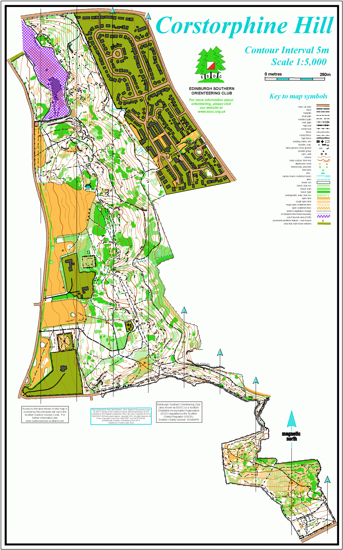
Map / Terrain
Terrain: Corstorphine Hill has plenty of contour features (as the name suggests), with detail in places. Some steeper slopes are often very slippery, whether muddy or icy, so shoes with studs or spikes are strongly recommended. The terrain is mainly forest, with some open areas. There are many crags and boulders, with only the larger ones mapped. There are many paths, and some smaller and less distinct ones are not mapped. Much of the undergrowth shown by screens on the map has now completely died down in winter, although some mapping indicates brambles that are still unpleasant (particularly in open areas).
The forest has survived Storm Eorwyn fairly well. There are lots of new twigs and small branches on the ground, and a few newly fallen trees. Most of these are easily avoided. Two have fallen over small paths that might be met on the Blue and Brown courses. The resulting thin line of fight will be shown on the map (probably via the overprint rather than editing the map, because the trees will probably be removed soon, perhaps even before the event).
Map: 1:5000 with 5 m contours. Peel Land Surveys 2019, extensively updated by Vicente Lopez 2023 and used for SoSOL in November 2023. A few minor revisions 2025. The dark green dashed line symbol is used to show the boundaries of patches of pine/fir trees in the forest.
The map will be printed on waterproof paper, the control descriptions will be printed on the map and there will be loose control descriptions at the Start. The map scale will likely be 1:5000 but the scale and size will be confirmed in the final details.
Safety Notes
- Other Users: Corstorphine Hill is very well used by the general public, including dog walkers, runners and bikers. Please respect their right to be there at the same time as you are orienteering.
- Dogs: Competitor’s dogs are allowed and should be kept under very close control at all times.
- SAFETY NOTE RE DOGS: Please give any dog walkers you encounter whilst running on your course extra space ie don’t run too close, especially if their dog/dogs are off lead. This applies to all competitors, not just those running with a dog. We always need to respect other people's right to be there.
- Weather: Please check the weather forecast on the day and dress appropriately. This event is on the edge of the city, but the weather is unpredictable in January and could be very cold, windy and wet. We recommend full leg cover for all competitors.
- Although the long range forecast means there should be no ice, it will be muddy and slippery especially on the wetland boardwalk.
- Course Closure Time: All courses have a closure time of 3pm after which controls will start to be brought in (before it gets dark. All competitors should be back at Download by 3pm.
- You must report to Download even if you do not complete your course, so we know you are back safely, and we don’t have to mount a search for you.
Course Information
Usual courses for a SoSOL ie Brown, Blue, Green, Short Green, Light Green, Orange, Yellow and White.
Provisional course lengths and note all courses have a fair degree of climb
Course | Length | Climb | # Controls | ||
| Brown | 7.5km | 320m | 31 | ||
| Blue | 5.9km | 205m | 23 | ||
| Green | 4.2km | 145m | 18 | ||
| Short Green | 3.5km | 135m | 19 | ||
| Light Green | 3.3km | 125m | 17 | ||
| Orange | 2.7km | 80m | 14 | ||
| Yellow | 1.9km | 100m | 15 | ||
| White | 1.3km | 80m | 16 |
- The Short Green course is not much shorter than the Green course, but this is what is suggested by the current guidelines.
- Note that the Brown course has 31 controls, which is beyond the capacity limit of older SI dibbers. Anyone affected by this, on this course only, will be contacted by EventAdmin and offered a SIAC dibber hire free of charge,.
- Three legs near the end of the Yellow course are at the upper end of level 2 difficulty – there are routes on paths but with quite a lot of junctions. On one leg people may pass a control that is found later on the course. There is no penalty if it is punched on passing the first time, but you must go back and punch again when it appears in the required sequence.
Plus we plan to have a String course near Registration.
Entry Details
Pre-Entry via Racesignup is required for this event. Entries will open on Saturday 1st February and will close at 8pm on Friday 14th February. To be guaranteed a map of your chosen course you MUST however pre-enter by 8pm on Monday 10th February.
Late pre-entries - late entries may be available after 8pm on Friday 14th if there are maps remaining by emailing email hidden; JavaScript is required
Entry on the day (EOD) - will be accepted at registration (10.30am – 12:45pm) on the day of the event assuming maps are still available. Payment by cash, bank transfer or card.
The RaceSignUp page will display the number of maps available (as an entry limit) on each course from Tuesday 11th
START TIMES: Starts will run from 11am to 1pm. Please choose an early start time (if you think you might take a long time out on your course. You must be back at Download by 3pm when courses close.
1. Entrants can select a 15 min start block from the range available at the time of making the entry on Race Sign Up
2. Please arrive at the Start in time to start within your chosen time block. It is not however necessary for everyone to be there at the beginning of their chosen block.
3. Juniors may be shadowed, please make this clear in the comments field on the entry form
You can view an entry list for all competitors and their chosen start blocks on RaceSignUp (scroll down to Start List section).
Entry Fees:
For this Regional event, unlike our Local events, we are only taking entries from individuals and pairs (sharing a map or dibber). Individual juniors may be shadowed, please make this clear in the comments field on the entry form.
To enter as a Student and pay the Junior/Young Adult fee, read the advice on the RaceSignUp page
| Individual Category | BOF Members | SOA Members | Non Members |
| Brown, Blue, Green, Short Green & Light Green Courses | |||
| Seniors (over 25) | £11.00 | £12.00 | £13.00 |
| Juniors/Students/Young adults (21-25) | £6.00 | £7.00 | £8.00 |
| Orange, Yellow & White Courses (ONLY) | |||
| Seniors (over 25) | £7.00 | £8.00 | £9.00 |
| Juniors/Students/Young adults (21-25) | £6.00 | £7.00 | £8.00 |
| Pairs | |||
| Additional Adult (over 26) | plus £1 | plus £1 | plus £1 |
| Additional Junior (under 25) | plus £0.50 | plus £0.50 | plus £0.50 |
SportIdent (SI) electronic timing will be used with the course controls SIAC enabled. Start and Finish units must be punched normally
SI card hire can be requested via the entry form,
- Free standard SI card hire but there will be a £30.00 charge if lost.
- Hire of SIAC (touch-free) cards is £2.50 and a charge of £60 will be made if lost.
If you would like to buy your own SI-Card then a variety are available directly from SportIdent UK. The choice may be confusing, and it may help you to know that the SI-Cards which ESOC hires out are very similar to the most basic model shown on the linked page - the SI-Card 8.
Registration and Start times
REGISTRATION: Registration and Download will both be in a tent visible from Corstorphine Road and will be open from 10.30am until 12.45pm. [TBC]
Start and Finish
Starts will run from 11am-1pm with course closure at 3pm. You should be back at Download by 3pm as controls will start to be brought in by 3pm so if you think you'll take a long time to complete your course please enter early so you can choose an early start time.(see Entry section for more details).
There will be 2 Starts
- The Near start for the White and Yellow courses will be less than 100 m from Registration.
- The Far start for other courses is 1.5 km and 75 m climb – west along Corstorphine Road past the Zoo, then turn right into steep Kaimes Road, climbing to the top, to the junction with Cairnmuir Road. It is possible to drive here and drop off very near the start, or even park nearby if you prefer the climb after your run rather than before!
There will be a dedicated bag drop tent at registration.
Facilities
We plan to have one toilet cubicle close to Registration, Plus there are numerous options for calling in at a supermarket or shopping centre on your way to the event.
'Informal toileting' is discouraged as this is a busy area for the public.
Dog restrictions
Well-behaved dogs are welcome so long as they are kept on a lead and do not distract other competitors.
Contacts / Officials
Early enquiries of any kind: email hidden; JavaScript is required
Entry enquiries once entries open: email hidden; JavaScript is required
Nearest A&E Hospital
See the details in the side panel
NHS Urgent care search