
Bonskeid map
Information
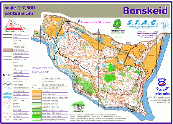
A small area of excellent terrain.
Bonskeid Estate is NW of Pitlochry, on the N side of the River Tummel at its confluence with the River Garry, bounded by these rivers and the B8019 road. The terrain is varied, mostly coniferous forest, and quite hilly, with some very detailed contours, as well as rock features and marshes.
The Bonskeid map is jointly owned with St Andrew's Orienteering Club (Glasgow).
Used for Regional events, and also a World Ranking Event in Scottish Spring 2016.
Location
/-3.788,56.7228,12/500x400?access_token=pk.eyJ1IjoicGF1bGZyb3N0IiwiYSI6ImNscGg3eGRlMjA0cm8yaW52aGhtY2lxZjQifQ.Lc483ZPI9QPGNrBpcqqywQ)
Near: Lat,Lng: 56.7228,-3.788 OS Grid Ref: NN905604 Postcode: PH16 5LD
Open an interactive map in: GoogleMap - OpenStreetMap - AppleMaps - BingMap